
Waitsburg, Washington
Waitsburg, Washington | |
|---|---|
 Waitsburg in 2019 | |
 Location of Waitsburg, Washington | |
| Coordinates: 46°16′5″N 118°9′15″W / 46.26806°N 118.15417°W | |
| Country | United States |
| State | Washington |
| County | Walla Walla |
| Area | |
| • Total | 1.16 sq mi (3.01 km2) |
| • Land | 1.16 sq mi (3.01 km2) |
| • Water | 0.00 sq mi (0.00 km2) |
| Elevation | 1,263 ft (385 m) |
| Population | |
| • Total | 1,166 |
| • Density | 1,058.47/sq mi (408.62/km2) |
| Time zone | UTC-8 (Pacific (PST)) |
| • Summer (DST) | UTC-7 (PDT) |
| ZIP code | 99361 |
| Area code | 509 |
| FIPS code | 53-75565 |
| GNIS feature ID | 1512768[3] |
| Website | City of Waitsburg |
Waitsburg is a city in Walla Walla County, Washington, United States. The population was 1,166 at the 2020 census.[2] Waitsburg has a unique city classification in Washington state, being the state's only city which still operates under its territorial charter.
Located on the Touchet River in an rural area of Southeastern Washington, Waitsburg has long been tied to the agricultural economy of its surrounding region. The milling of wheat played a prominent role in the first century of Waitsburg's existence, though in recent decades the economy has pivoted towards viticulture and tourism due to its location within the Walla Walla AVA. The downtown core of the community, dating to the 1880s, is listed on the National Register of Historic Places as the Waitsburg Historic District.
History
[edit]Prior to settlement by European American pioneers, the area that is now Waitsburg was home to the Palouse people. The juncture of the Touchet River and Coppei Creek, where Waitsburg would eventually develop, was recorded in the journals of the Lewis and Clark Expedition during their return trip in 1806.[4]
Waitsburg was first settled in 1859 by Robert Kennedy. Another early settler, Albert Gallatin Lloyd, helped settle persistent confrontations with the Palouse people by negotiating a treaty allowing the native population to camp on the land that he claimed. The arrangement established by that treaty, though not backed up by law, continued informally into the 1940s.[4] William Perry Bruce and his wife, Caroline, moved to Waitsburg in 1861, some two decades before Waitsburg was officially incorporated on November 25, 1881. In 1882, they built a large home in the town, which today functions as a museum.[5]
Early settlers raised cattle and horses and grew grain along the banks of the Touchet River and the creeks which feed into it. During the 1860s, dryland farming of the adjacent hills led to expansion of wheat production around Waitsburg. That development, along with the discovery of gold in the valley of the Clearwater River to the east, brought an influx of population to the area. Due to the mining boom in the Clearwater region, a stagecoach line was established connecting Walla Walla in the west with Lewiston, Idaho, at the juncture of the Clearwater and Snake Rivers, to the east, passed through what would become Waitsburg, bringing travelers heading to and from the mines. This connection between the nascent Waitsburg community and the mining district led to a meeting between Dennis Willard, a landowner in the Waitsburg area, and Sylvester M. Wait, in Lewiston in 1864. Willard convinced Wait of the potential to ship wheat flour down the Touchet valley and allowed him to establish a mill on his land that same year.[4] The city of Waitsburg would later be named for Sylvester M. Wait.[6][7]
.jpeg)
With the establishment of the mill, a community began to coalesce around Wait's mill which included a school, saloon, store, hotel and post office.[4] The town was platted in 1869 and named Waitsburg.[8] By 1870, the town was home to over 100 residents in 35 dwellings and an assortment of businesses. N. J. A. Smith, an early settler and schoolmaster, called Waitsburg the only place of note between Walla Walla and Lewiston. Waitsburg's notability continued to expand throughout the 1870s, during which it would be connected by telegraph line to Portland, Oregon and with the establishment of a newspaper, the Waitsburg Times.[4]
.jpeg)
Disaster struck on September 13, 1880, when a fire ravaged the town's business district. The area was quickly rebuilt, this time with brick, and a year later, in 1881, the Oregon Railroad and Navigation Company completed a line through Waitsburg connecting it by rail with Walla Walla and the outside world. On November 25 of 1881, the city was officially incorporated as the City of Waitsburg. The original charter was revised five years later, in 1886, and the revised charter has been in place ever since. It was under the revised charter that official city services like police, fire and utilities came to the community. Waitsburg's commercial importance as a mill town continued to grow throughout this decade and the Walt's Mill, no longer owned by Walt and eventually known as Washington Mills was expanded and improved, notably with the introduction of steel machinery. By the end of the decade in 1890, Waitsburg's population exceeded 800 people.[4]
The mill continued to be the economic heart of Waitsburg through the late 1800s and into the mid-20th century. In 1936 it was converted from a water-powered mill to electric. It would operate as an electric mill for over two decades until it was closed down in 1957. The abandoned mill stood until a fire destroyed it in 2009.[4] Despite the closure of the mill, Waitsburg remained relatively stable economically and in terms of population throughout the second half of the 20th century as a commercial center supporting the surrounding agricultural region.
Since the turn of the 21st century, Waitsburg's economic fortunes have been bolstered by the growth of the wine industry.[4] The community is located in the Walla Walla AVA and has become a destination for wine tourists. During the first two decades of the 21st century, numerous businesses were established catering to these tourists including specialty restaurants, bars and hotels.[4][9] Waitsburg's culinary scene was recognized nationally in 2024 when Bar Barcello was one of 10 nominees for the 2024 James Beard Award for Best New Restaurant.[10]
Historic places
[edit]| [11] | Name on the Register | Image | Date listed[12] | Location | City or town | Description |
|---|---|---|---|---|---|---|
| 1 | William Perry Bruce House |  |
November 20, 1975 (#75001878) |
318 Main St. 46°16′07″N 118°09′15″W / 46.268611°N 118.154167°W | Waitsburg | Built in the Victorian Italianate style in 1883 by William Perry Bruce, a founding settler of Waitsburg. Now the Bruce Memorial Museum, run by the Waitsburg Historical Society.[13] |
| 2 | Preston Hall |  |
January 12, 1993 (#92001590) |
600 Main St. 46°15′59″N 118°09′12″W / 46.266389°N 118.153333°W | Waitsburg | |
| 3 | Waitsburg High School |  |
April 25, 2001 (#01000431) |
421 Coopei St. 46°16′01″N 118°09′05″W / 46.266944°N 118.151389°W | Waitsburg | |
| 4 | Waitsburg Historic District |  |
March 31, 1978 (#78002784) |
Main St. 46°16′19″N 118°09′11″W / 46.271944°N 118.153056°W | Waitsburg |
Geography
[edit]
According to the United States Census Bureau, the city has a total area of 1.12 square miles (2.90 km2), all of it land.[14]
Waitsburg is located in the valley of the Touchet River in Southeastern Washington. The Touchet River passes along the northern edge of the town and is joined by Wilson Creek, which passes through the eastern portion of Waitsburg, and Coppei Creek, which flows through the western portion. The thin valley of the Touchet River sits at roughly 1,300 feet above sea level at Waitsburg with hillsides rising to roughly 1,700 feet within a mile of the town to both the north and the south.[15] The surrounding terrain of rolling hills is covered with farmland dominated by wheat and barley.[9]
U.S. 12 passes through Waitsburg, where it meets Washington State Route 124. U.S. 12 enters Waitsburg from the south along Coppei Avenue before turning east at Preston Avenue. Route 124 enters from the west along 2nd Avenue before terminating at U.S. 12 at the intersection of Coppei and Preston Avenues.[15]
Climate
[edit]This region experiences warm (but not hot) and dry summers, with no average monthly temperatures above 71.6 °F (22 °C). According to the Köppen Climate Classification system, Waitsburg has a warm-summer Mediterranean climate, abbreviated "Csb" on climate maps.[16]
| Climate data for Waitsburg, Washington | |||||||||||||
|---|---|---|---|---|---|---|---|---|---|---|---|---|---|
| Month | Jan | Feb | Mar | Apr | May | Jun | Jul | Aug | Sep | Oct | Nov | Dec | Year |
| Mean daily maximum °C (°F) | 4 (40) |
7 (45) |
12 (53) |
16 (61) |
21 (69) |
25 (77) |
31 (87) |
30 (86) |
24 (76) |
18 (64) |
9 (49) |
5 (41) |
17 (62) |
| Mean daily minimum °C (°F) | −4 (25) |
−2 (29) |
1 (34) |
3 (38) |
7 (44) |
10 (50) |
13 (55) |
12 (54) |
8 (47) |
4 (39) |
0 (32) |
−3 (27) |
4 (39) |
| Average precipitation mm (inches) | 61 (2.4) |
48 (1.9) |
53 (2.1) |
41 (1.6) |
41 (1.6) |
33 (1.3) |
13 (0.5) |
13 (0.5) |
23 (0.9) |
41 (1.6) |
64 (2.5) |
64 (2.5) |
490 (19.3) |
| Source: Weatherbase [17] | |||||||||||||
Transportation
[edit] - U.S. 12 - to Walla Walla (west) and Dayton (east)
 - State Route 124 - to Prescott (west)
Demographics
[edit]| Census | Pop. | Note | %± |
|---|---|---|---|
| 1880 | 248 | — | |
| 1890 | 817 | 229.4% | |
| 1900 | 1,011 | 23.7% | |
| 1910 | 1,237 | 22.4% | |
| 1920 | 1,174 | −5.1% | |
| 1930 | 869 | −26.0% | |
| 1940 | 936 | 7.7% | |
| 1950 | 1,015 | 8.4% | |
| 1960 | 1,010 | −0.5% | |
| 1970 | 953 | −5.6% | |
| 1980 | 1,035 | 8.6% | |
| 1990 | 990 | −4.3% | |
| 2000 | 1,212 | 22.4% | |
| 2010 | 1,217 | 0.4% | |
| 2020 | 1,166 | −4.2% | |
| U.S. Decennial Census[18] | |||
2010 census
[edit]As of the 2010 census,[19] there were 1,217 people, 475 households, and 328 families residing in the city. The population density was 1,086.6 inhabitants per square mile (419.5/km2). There were 522 housing units at an average density of 466.1 per square mile (180.0/km2). The racial makeup of the city was 93.1% White, 0.2% African American, 1.5% Native American, 0.7% Asian, 0.2% Pacific Islander, 1.9% from other races, and 2.3% from two or more races. Hispanic or Latino of any race were 5.3% of the population.
There were 475 households, of which 37.5% had children under the age of 18 living with them, 53.3% were married couples living together, 10.7% had a female householder with no husband present, 5.1% had a male householder with no wife present, and 30.9% were non-families. 25.7% of all households were made up of individuals, and 14.7% had someone living alone who was 65 years of age or older. The average household size was 2.56 and the average family size was 3.04.
The median age in the city was 41 years. 26.4% of residents were under the age of 18; 8% were between the ages of 18 and 24; 21.2% were from 25 to 44; 28.4% were from 45 to 64; and 16.1% were 65 years of age or older. The gender makeup of the city was 49.6% male and 50.4% female.
2000 census
[edit]As of the 2000 census, there were 1,212 people, 490 households, and 314 families residing in the city. The population density was 1,279.5 people per square mile (492.6/km2). There were 522 housing units at an average density of 551.1 per square mile (212.2/km2). The racial makeup of the city was 94.80% White, 0.58% African American, 0.41% Native American, 0.66% Asian, 1.16% from other races, and 2.39% from two or more races. Hispanic or Latino of any race were 2.81% of the population.
There were 490 households, out of which 32.9% had children under the age of 18 living with them, 51.0% were married couples living together, 9.0% had a female householder with no husband present, and 35.9% were non-families. 31.4% of all households were made up of individuals, and 15.9% had someone living alone who was 65 years of age or older. The average household size was 2.47 and the average family size was 3.13.
In the city, the age distribution of the population shows 29.7% under the age of 18, 5.4% from 18 to 24, 24.8% from 25 to 44, 23.5% from 45 to 64, and 16.6% who were 65 years of age or older. The median age was 39 years. For every 100 females, there were 97.4 males. For every 100 females age 18 and over, there were 92.3 males.
The median income for a household in the city was $33,527, and the median income for a family was $40,865. Males had a median income of $31,625 versus $21,518 for females. The per capita income for the city was $16,803. About 10.6% of families and 14.0% of the population were below the poverty line, including 14.8% of those under age 18 and 10.0% of those age 65 or over.
Gallery
[edit]-
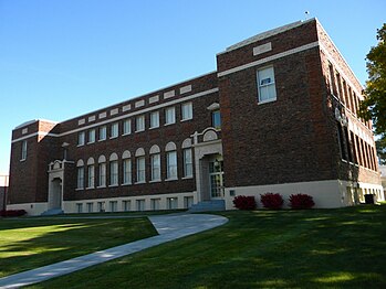 Waitsburg High School
 -
 Bruce House
 -
 Downtown Waitsburg in 2006
 -
 Preston Hall


References
[edit]- ^ "2019 U.S. Gazetteer Files". United States Census Bureau. Retrieved August 7, 2020.
- ^ a b "Waitsburg city, Washington". United States Census Bureau. 2020. Retrieved August 10, 2022.
- ^ "US Board on Geographic Names". United States Geological Survey. October 25, 2007. Retrieved January 31, 2008.
- ^ a b c d e f g h i Paulus Jr., Michael J. (August 12, 2011). "Waitsburg — Thumbnail History". historylink.org. HistoryLink. Retrieved September 27, 2024.
- ^ http://www.waitsburghistoricalsociety.org/index.html museum
- ^ Majors, Harry M. (1975). Exploring Washington. Van Winkle Publishing Co. p. 138. ISBN 978-0-918664-00-6.
- ^ Meany, Edmond S. (1923). Origin of Washington geographic names. Seattle: University of Washington Press. p. 330.
- ^ "Revisiting Washington — Waitsburg". revisitwa.org. Washington Trust for Historic Preservation. Retrieved September 28, 2024.
- ^ a b "Waitsburg, Washington". sunset.com. Sunset Magazine. Retrieved September 27, 2024.
- ^ Musho, Lee (May 14, 2024). "Meet the James Beard Nominees for Best New Restaurant". eater.com. Vox Media. Retrieved September 28, 2024.
- ^ Numbers represent an alphabetical ordering by significant words. Various colorings, defined here, differentiate National Historic Landmarks and historic districts from other NRHP buildings, structures, sites or objects.
- ^ The eight-digit number below each date is the number assigned to each location in the National Register Information System database, which can be viewed by clicking the number.
- ^ Robert Wayne Hergert (March 12, 1975). "National Register of Historic Places Inventory-Nomination: William Perry Bruce House". National Park Service.
- ^ "US Gazetteer files 2010". United States Census Bureau. Retrieved December 19, 2012.
- ^ a b "Waitsburg Quadrangle". usgs.gov. U.S. Geological Survey. Retrieved September 27, 2024.
- ^ Climate Summary for Waitsburg, Washington
- ^ "Weatherbase.com". Weatherbase. 2014. Retrieved on June 4, 2014.
- ^ United States Census Bureau. "Census of Population and Housing". Retrieved July 21, 2014.
- ^ "U.S. Census website". United States Census Bureau. Retrieved December 19, 2012.
External links
[edit]Municipalities and communities of Walla Walla County, Washington, United States | ||
|---|---|---|
| Cities |  | |
| CDPs | ||
| Unincorporated communities | ||
| Ghost towns | ||
| International | |
|---|---|
| National | |